Coordinates 7.0

We are happy to announce a big update for Coordinates.

Coordinates 7.0

Screenshot 2020-12-02 at 14.01.27.png

[50+ new coordinates formats]

  • More than 50 new coordinates to choose from (Quick access menu)

  • EPSG:2462 / Albanian 1987 / Gauss-Kruger zone 4

  • EPSG:3102 / American Samoa 1962 / American Samoa Lambert

  • EPSG:2195 / NAD83(HARN) / UTM zone 2S

  • EPSG:2000 / Anguilla 1957 / British West Indies Grid

  • EPSG:2001 / Antigua 1943 / British West Indies Grid

  • EPSG:24819 / PSAD56 / UTM zone 19N

  • EPSG:2317 / PSAD56 / ICN Regional

  • EPSG:3112 / GDA94 / Geoscience Australia Lambert

  • EPSG:3577 / GDA94 / Australian Albers

  • EPSG:3416 / ETRS89 / Austria Lambert

  • EPSG:20499 / Ain el Abd / Bahrain Grid

  • EPSG:25884 / ETRS89 / TM Baltic93

  • EPSG:3106 / Gulshan 303 / Bangladesh Transverse Mercator

  • EPSG:21292 / Barbados 1938 / Barbados National Grid

  • EPSG:3812 / ETRS89 / Belgian Lambert 2008

  • EPSG:31370 / Belge 1972 / Belgian Lambert 72

  • EPSG:5589 / Sibun Gorge 1922 / Colony Grid

  • EPSG:3770 / BDA2000 / Bermuda 2000 National Grid

  • EPSG:5266 / DRUKREF 03 / Bhutan National Grid

  • EPSG:5530 / SAD69(96) / Brazil Polyconic

  • EPSG:3920 / Puerto Rico / UTM zone 20N

  • EPSG:5247 / GDBD2009 / Brunei BRSO

  • EPSG:3978 / NAD83 / Canada Atlas Lambert

  • EPSG:3347 / NAD83 / Statistics Canada Lambert

  • EPSG:4826 / WGS 84 / Cape Verde National

  • EPSG:5367 / CR05 / CRTM05

  • EPSG:3766 / HTRS96 / Croatia LCC

  • EPSG:3765 / HTRS96 / Croatia TM

  • EPSG:5513 / S-JTSK / Krovak

  • EPSG:2002 / Dominica 1945 / British West Indies Grid

  • EPSG:5460 / Ocotepeque 1935 / El Salvador Lambert

  • EPSG:26237 / Massawa / UTM zone 37N

  • EPSG:3301 / Estonian Coordinate System of 1997

  • EPSG:5316 / ETRS89 / Faroe TM

  • EPSG:3460 / Fiji 1986 / Fiji Map Grid

  • EPSG:3067 / ETRS89 / TM35FIN(E,N) -- Finland

  • EPSG:2154 / RGF93 / Lambert-93 -- France

  • EPSG:5523 / WGS 84 / Gabon TM 2011

  • EPSG:5223 / WGS 84 / Gabon TM

  • EPSG:5243 / ETRS89 / LCC Germany (E-N)

  • EPSG:25000 / Leigon / Ghana Metre Grid

  • EPSG:5938 / WGS 84 / EPSG Greenland Polar Stereographic

  • EPSG:2003 / Grenada 1953 / British West Indies Grid

  • EPSG:4559 / RRAF 1991 / UTM zone 20N

  • EPSG:4414 / NAD83(HARN) / Guam Map Grid

  • EPSG:2095 / Bissau / UTM zone 28N

  • EPSG:2326 / Hong Kong 1980 Grid System

  • EPSG:5325 / ISN2004 / Lambert 2004

  • EPSG:3893 / ED50 / Iraq National Grid

  • EPSG:6646 / Karbala 1979 / Iraq National Grid

  • EPSG:2039 / Israel 1993 / Israeli TM Grid

  • EPSG:3448 / JAD2001 / Jamaica Metric Grid

  • EPSG:3066 / ED50 / Jordan TM

  • EPSG:24600 / KOC Lambert

  • EPSG:22780 / Deir ez Zor / Levant Stereographic

  • EPSG:22770 / Deir ez Zor / Syria Lambert

  • EPSG:3177 / LGD2006 / Libya TM

  • EPSG:3346 / LKS94 / Lithuania TM

  • EPSG:2169 / Luxembourg 1930 / Gauss

  • EPSG:20936 / Arc 1950 / UTM zone 36S

  • EPSG:29702 / Tananarive (Paris) / Laborde Grid approximation

  • EPSG:4026 / MOLDREF99 / Moldova TM

  • EPSG:2004 / Montserrat 1958 / British West Indies Grid

  • EPSG:28992 / Amersfoort / RD New -- Netherlands - Holland - Dutch

  • EPSG:3163 / RGNC91-93 / Lambert New Caledonia

  • EPSG:3851 / NZGD2000 / NZCS2000

  • EPSG:28192 / Palestine 1923 / Palestine Belt

  • EPSG:5469 / Panama-Colon 1911 / Panama Lambert

  • EPSG:5472 / Panama-Colon 1911 / Panama Polyconic

  • EPSG:3783 / Pitcairn 2006 / Pitcairn TM 2006

  • EPSG:2180 / ETRS89 / Poland CS92

  • EPSG:3763 / ETRS89 / Portugal TM06

  • EPSG:4437 / NAD83(NSRS2007) / Puerto Rico and Virgin Is.

  • EPSG:28600 / Qatar 1974 / Qatar National Grid

  • EPSG:3844 / Pulkovo 1942(58) / Stereo70

  • EPSG:2005 / St. Kitts 1955 / British West Indies Grid

  • EPSG:2006 / St. Lucia 1955 / British West Indies Grid

  • EPSG:4467 / RGSPM06 / UTM zone 21N

  • EPSG:2007 / St. Vincent 45 / British West Indies Grid

  • EPSG:2318 / Ain el Abd / Aramco Lambert

  • EPSG:31028 / Yoff / UTM zone 28N

  • EPSG:3414 / SVY21 / Singapore TM

  • EPSG:3794 / Slovenia 1996 / Slovene National Grid

  • EPSG:5179 / Korea 2000 / Unified CS

  • EPSG:2062 / Madrid 1870 (Madrid) / Spain

  • EPSG:5234 / Kandawala / Sri Lanka Grid

  • EPSG:5235 / SLD99 / Sri Lanka Grid 1999

  • EPSG:31121 / Zanderij / UTM zone 21N

  • EPSG:3829 / Hu Tzu Shan 1950 / UTM zone 51N

  • EPSG:25231 / Lome / UTM zone 31N

  • EPSG:5887 / TGD2005 / Tonga Map Grid

  • EPSG:2163 / US National Atlas Equal Area

[Custom formats]

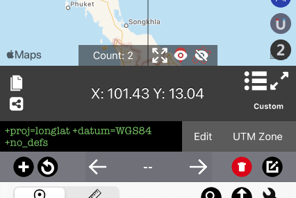
  • New custom format section to record coordinates with any format! It’s now possible to specify your own coordinates in proj.4 format and record them. Or search more than 10000+ formats from online database.

  • Search and select 10000+ coordinates format from search menu.

  • Supported specified UTM zone conversion


[UI enhancement and fixes]

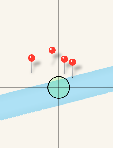
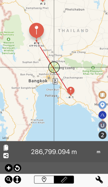
  • Show number of points on the map

  • Zoom out to show all coordinates points

  • Show line between points

  • Scroll search menu to the top when pressing WGS84 section

  • Performance improvement

Rainy Season Update

Hello all, it’s been almost six month since my previous post. Time flies.

As we know, 2020 is not a great year for most of us. Pandemic, Covid-19, economy, etc. I wish everyone stay safe and healthy.

Six months as a registered company was a rocky road for me. I had to learn basic accounting, although I did hired an accountant to help with most business transactions. I had to live two months without salary due to banking information issue on my corporate account. Problem is now resolved, now I’m just back on track.

As for app, there are not many big updates. They are now iOS 14 ready at this point but doesn’t have any new feature specific to this version of iOS just yet. (If you need Widget please let me know)

I put most of my afford on Coordinates app thanks to awesome feedback emails from everyone. I added over 10 new coordinates format and several new features. So many new features that I need to rewrite most of the instruction which is pretty much out of date.

Anyway, if you are users of other apps, please send email for any suggestion of new features. I will add it asap as well!.

Thanks for using our apps. Have a nice weekend!

Apikrit

Mapnitude Company Limited

Hello,

Sorry for not having much update since the new year. There’s a lot going on in the background.

Here are some great news.

Mapnitude is now a registered company.

As you can see, it is shown on the App Store as the company name instead of my name.

Transition period will take a while. Every aspect of the app will be the same, except that I will work on it more seriously than before.

By the way, COVID-19 situation seems it get worse. Please avoiding crowded public spaces and wash your hands.

Have a good day.

Apikrit

Preparing for Christmas

Hello everyone, It’s about a week away from Christmas. Which is important to us because we couldn’t submit any update to the App Store during the holiday.

So far we released updates to all of our apps to fixed search bug and also dark mode bug that prevent some apps to work properly. Please update the app to latest version of the problem still persist in your device.

Although we still have more update about to roll-in but it’s safer for us here to release new feature updates after the new year. Please stay tuned.

Happy Holiday and see you next year!

Update to August 2019 Roadmap

From this post

Well, we admit that we are bad at sticking to the plan.

Here’s what we actually did in August so far

Released Elevation 4.0 with Barometer measurement

Released Coordinates 6.0 with bunches of new features.

What will we do next?

We will try bringing Indian Kalianpur to Coordinates for Android.

Coordinates Android Version 3.9 now has Indian Kalianpur conversion

Then we would like to take a short break, then we will add new features to Distance for iOS.

We will take a week break from now…. unless you report some bugs and we will go fix it.

Again, we hope you will enjoy our apps.


Introducing Coordinates 6.0

Good evening,

We’re so delighted to announce you the latest update to Coordinates App

Coordinates 6.0

 
iPhone Xs Max-01Coordinates - Display_framed.png
 

Let’s go through all big new features

Export / Import feature with Airdrop support (Including GPX format)

 
iPhone Xs Max-07Coordinates - ImExport_framed.png
 

Access this menu by going to “Coordinates list” menu first. We moved the button to the top to make it a lot easier to see.

Screenshot 2019-08-21 02.18.26.png

You may import/export current coordinates list between iOS devices. by attaching exported txt/gpx file, copy paste raw text file, transfer via Airdrop, and more.

Yes! .gpx file support is here!

Export .gpx file to other apps, Garmin GPS, and more. And you may import the coordinates back into the app too!

import data tutorial

By the way, let’s go through how the app can import .gpx file

Here is how the app see .gpx file or supported .txt file in email app

 
IMG_6F3ECA5855AA-1.jpeg
 

Once you tap on the file, you may need to tap on the “Open in” button again

 
IMG_3213.jpg
 

and then select Coordinates app.


You may need to swipe to the right if you can’t find coordinates app

 
IMG_3215.jpg
 

After that, press “Import data” to begin importing data.

You will have option to choose between replacing all existing coordinates or append to existing list.


Quick pin navigation

Main focus here is the new grey “Pin Navigation Bar”.

Screenshot 2019-08-21 01.57.39.png

Press arrow buttons to browse between selected pin. Pin name is shown on the middle, and you may edit pin informations by pressing on it.

Screenshot 2019-08-21 01.57.44.png

You no longer have to go to the list menu to edit pin name.

If you wish to change pin format. you may do that by selecting new format first then press overwrite result.

Screenshot 2019-08-21 01.57.54.png

Just like that, no need to drop pin again to make change!

Distance measurement

Screenshot 2019-08-21 02.03.37.png

Press ruler button to begin distance measurement.

Then you may measure distance between pin or just draw your own line

Screenshot 2019-08-21 02.03.55.png

It just works. Just like Area app!

*Version 6.0 doesn’t yet support saving of distance data.

And there are a lot more features Please check change logs down below.

We will keep the same subscribe pricing probably until we finish implementing distance measurement feature.

As usual, if you subscribe now, you get the same price forever!

Closing note:

It’s been a busy August for us. Many weeks of lacking sleep, but we’re very happy with the result. We’ve done coding Elevation 4.0 and Coordinates 6.0. And we believe both update are really awesome.

Most importantly, we hope you will enjoy using the app as well!

Have a great day,

Apikrit


Version 6.0 Full Change log


[New features]

Export / Import feature with Airdrop support (Including GPX format)

- Export current coordinates list to e-mail attachment and many more.

- Custom made XML format with all information and standard GPX format.

- Import .txt created previously to migrate or backup coordinates data between device.

- Open gpx file and .txt (made by this app) from e-mail, Files app, and many more.

- Share current coordinates list via Airdrop

- Append to existing coordinates list (also check for duplication) or start over.

Quick pin navigation

- Go to previous/next pin

- Rename pin directly on the map screen

- Overwrite pin result (Change format)

Distance measurement

- Measure distance between pin points

- Add your own line

- Share result of current measurement

*For current version. Distance measurement is temporary. It will not be saved.

Additional optimisation

- Double warning for map screen Delete All button. To precent accident deletion.

- Updated UI for above feature sets

- More stand-out Save/Load and Import/Export button in list menu

- Share secondary coordinates

- Tweeked list menu

[Bug fix]

Fixed layout issue which caused crash when rotating the device

Fixed bad translation on few texts

Fixed bad button positioning

Fixed overlapping label on big view.


Introducing: Elevation 4.0

Hello,

It’s finally halfway through August. Quite a rainy season here in Thailand.

Today, I’m delight to tell you about major update to Elevation app.

Elevation 4.0

 
iPhone Xs Max-01Elevation - Line2_framed.png
 

You may notice some changes in the interface. This is to make browsing the app much more intuitive. Select Mode -> Then start measurement.

Another big update to this app is that we feature more elevation data source. Starting from cloud mode, GPS mode, and a new mode……..

Barometer Mode

 
iPhone Xs Max-02Elevation - Track_framed.png
 

We didn’t make screenshot for Barometer mode, but it look quite the same as GPS mode.

Air pressure toolbar is included in every mode. In barometer mode, it will use current pressure to calculate for elevation. While other mode will use elevation data to calculate air-pressure at that exact elevation.

You may calibrate or add extra offset within the toolbar.

And not only that, we included dedicated barometer and air-pressure calculator to use within the app too!

iPhone Xs Max-03Elevation - Barometer_framed.png
iPhone Xs Max-04Elevation - Calc_framed.png

Not only that we also offer export function for GPS and Barometer mode, so you could use collected data for other purpose as well.

Version 4.0 Change logs
- New UI
- Switch coordinates bar on/off on the main page
- New data source: Barometer
- Barometer toolbar
- Dedicated Barometer page
- Air Pressure <> Altitude calculator
- GPS signal indicator
- Export mode for GPS and Barometer mode

Instruction will be updated later this week.

We hope you will enjoy this update.