
Coordinates 9.6.0 is here, and it's packed with new features to enhance your mapping workflow. Whether you're a surveyor, field technician, or hobbyist, this update makes your mapping more powerful and flexible.
📸 Attach Photos to Pins, Labels, and Shapes
You can now attach photos to any map object—pins, labels, or shapes. Capture site details, field notes, or visual markers, and export them seamlessly along with your coordinate data.


✅ Photos are visible on the map when pin display mode is set to 3.
🏷️ You Can Swap Pin and Label Directly
Sometimes a point is better off as a label, and sometimes a label should become a point again. In this update, you can now convert between pins and labels directly in the Rename view. Just tap the “Convert” button, and your pin instantly becomes a label—or vice versa. No need to delete and recreate anything.
This feature is perfect for cleaning up your map and keeping your annotations exactly how you want them.

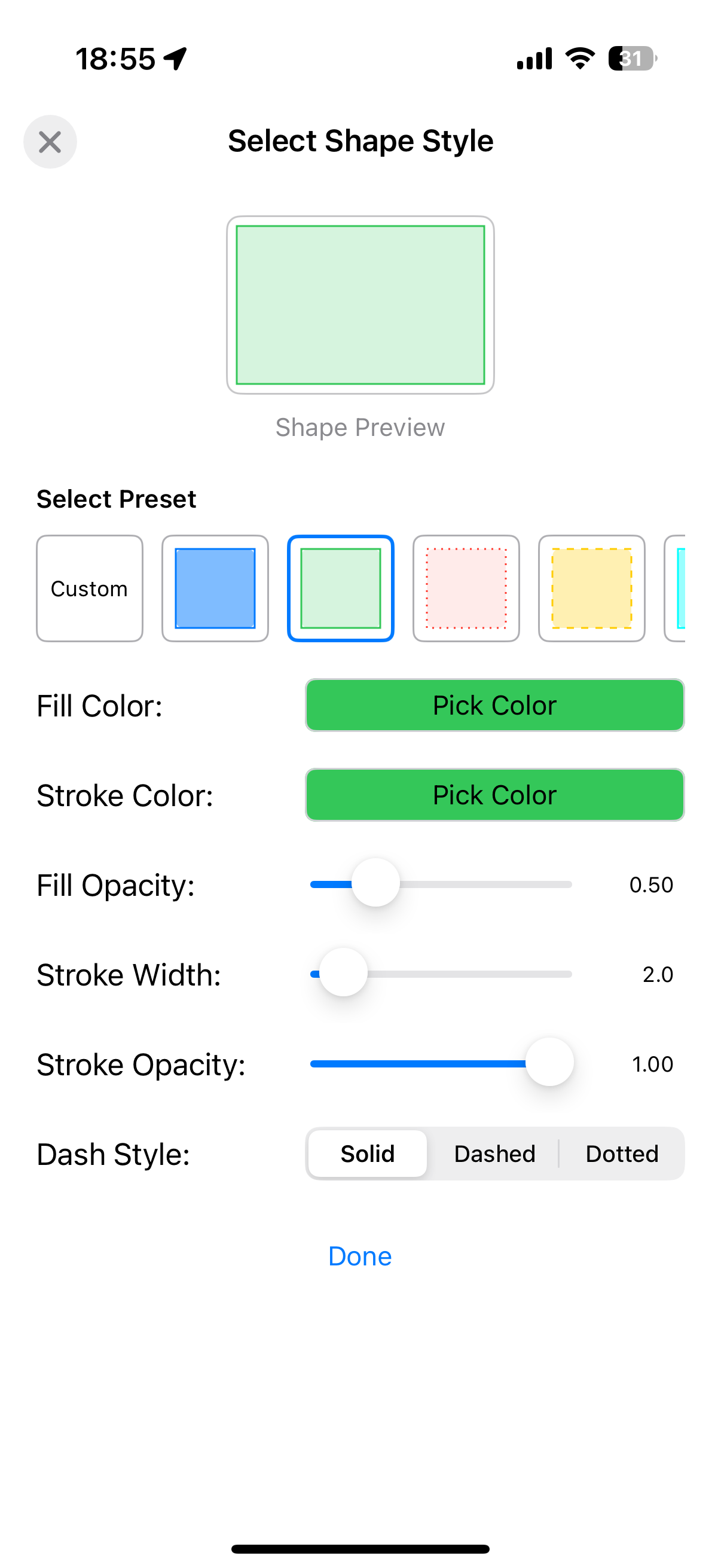
🎨 Easily Reselect Shape Style
Sometimes you draw a shape, and later you realize the color or stroke wasn’t quite right. With this update, you can easily reselect the style of any shape—whether it’s a circle, line, or polygon—without having to redraw it from scratch.
Tap the “Reselect Style” button in the Rename view, and you can adjust the fill color, stroke width, opacity, and line pattern instantly.
This feature is perfect for fine-tuning the look of your map and making sure every shape stands out the way you want. No more deleting and recreating shapes just to change their style!

🌍 Import and Export: GPX, GeoJSON, KML, and Survey CSV
Your maps, your data, anywhere you need them. With this update, Coordinates now supports importing and exporting in multiple standard formats:
GPX – for GPS devices and navigation apps
GeoJSON – for web maps and GIS workflows
KML – for Google Earth and 3D map viewers
Survey CSV – for structured field data

You can now:
✅ Import external data sets into Coordinates to build on top of them
✅ Export your pins, labels, and shapes to standard formats for use in other tools
✅ Seamlessly move your data between mobile, desktop, and cloud
With these features, Coordinates becomes a powerful map overlay editor—a complete solution for creating, managing, and sharing spatial data right on your device.
🔄 Batch Coordinates Converter
Convert multiple coordinates at once—up to 5 at a time for free users. Premium users can unlock unlimited batch conversion and add converted points directly to the map.
Access the Batch Converter from the Action menu.
Supported formats for both input and output include:
Decimal Degrees
DMS (Degrees, Minutes, Seconds)
DDM (Degrees, Decimal Minutes)
UTM
MGRS
GEOREF
GARS
ISO 6709
Plus Code
QTH/Maidenhead
BNG/OSGB Grid
Geohash
(See attached screenshot for details)


🚀 App-wide EPSG Lookup: Just Type the Code!
If you know the EPSG number, you’re all set.
No more visiting websites or pasting Proj4 strings.
Just type the number—the app fetches the Proj4 string automatically.
✅ Load into the map
✅ Save as a preset
✅ Copy with a tap
Easy, fast, and seamless.
🎨 Fresh UI and Shape Tools
Enjoy a modernized interface with improved usability, along with enhanced shape drawing tools. Whether you're working with lines, polygons, or circles, the new tools make it easier than ever to create and export shapes.
🚀 Upgrade Now
Download Coordinates 9.6.0 and take your mapping to the next level.