

Coordinates – GPS Converter
The Ultimate Mapping Toolkit
★★★★★
5 k+ reviews, 4.7 average
10 years in development, monthly updates
“Powerful and user-friendly tool for anyone working with geographic locations”
“I am a biologist that heavily relies on marked sites. This app is the best.”
“Thank you devs for making an app that does what it’s meant for!”
“The Developer
Was extremely helpful and quick with the responses to some issues I had.”

Powerful. Portable. Synchronized.
Coordinates works seamlessly across your devices
whether you're in the field with your Apple Watch or analyzing data on your iPhone.
Convert, locate, and track — anytime, anywhere.
“Coordinates was built on precision — and our flagship converter is still the most accurate and flexible on the App Store.”

Universal Coordinate Converter
Convert between GPS, UTM, MGRS, EPSG, and over 200 global formats — all in one place.
🧭 Key Highlights:
Supports popular systems like WGS84, DMS, MGRS, what3words, Geohash, Georef, Maidenhead, and more
Real-time sync across all formats
One-tap copy, share, and map preview
Designed for surveyors, radio operators, GIS users, and explorers alike
“It’s the most complete coordinate converter I’ve ever used — fast, accurate, and reliable.”
Map-aware by design, user-focused by nature.
🧭 Built for map-based UX
Harness the power of real-time orientation, live overlays, and interactive geolocation — all with pinpoint accuracy.
🛠 Key Features:
✅ Compass + bearing overlay
Visualize exact heading and orientation at a glance
✅ Location-aware UI
All tools adapt to where you are — and where you're facing
✅ Smart coordinate output
Latitude/Longitude, UTM, and custom projections all in one view
“It’s not just a compass. It’s a design layer built on location.”


Real-Time Navigation
Track your location live with high-precision coordinates and visual guidance.
🌍 Key Features:
Supports multiple coordinate formats (MGRS, USNG, UTM, etc.)
Displays horizontal accuracy, elevation, and time in real time
Route distance and direction to selected point
Large-text mode for outdoor visibility
“Perfect for fieldwork, surveying, or simply finding your way with accurate map-based data.”
Precision Measuring Made Simple
Plan smarter with Coordinates' built-in measuring tool — designed for field accuracy and simplicity.
🛠 Key Features:
✅ Live Distance/Area Readout
Segment-by-segment length
Final bearing, total length, total area
Automatic unit conversion
✅ Map-Synced Marking
See real-time shape overlay on Apple Maps
“The measurement tool alone is worth the app.”

🚀 What’s New in 2025
We’ve worked harder than ever to bring you the most powerful update yet. After 3 intense months of rewriting, refining, and rebuilding — we’ve delivered what feels like five years' worth of progress in a single update.
Version 9.x is a major leap forward, packed with features designed for both professionals and explorers: smarter tools, cleaner UI, and new ways to measure, convert, and map your world.

Draw & Annotate on the Map
Mark areas, paths, and points
Color-coded zones and labels
Export to .KML, .GPX, .geoJSON

Add Notes, Photos & Videos
Save timestamp, location & notes
Add photo/video to any point
Convert or reformat anytime

User Grid Setup
Define custom projection (EPSG or PROJ4)
Adjust scale, offsets, and units
Ideal for surveyors & researchers
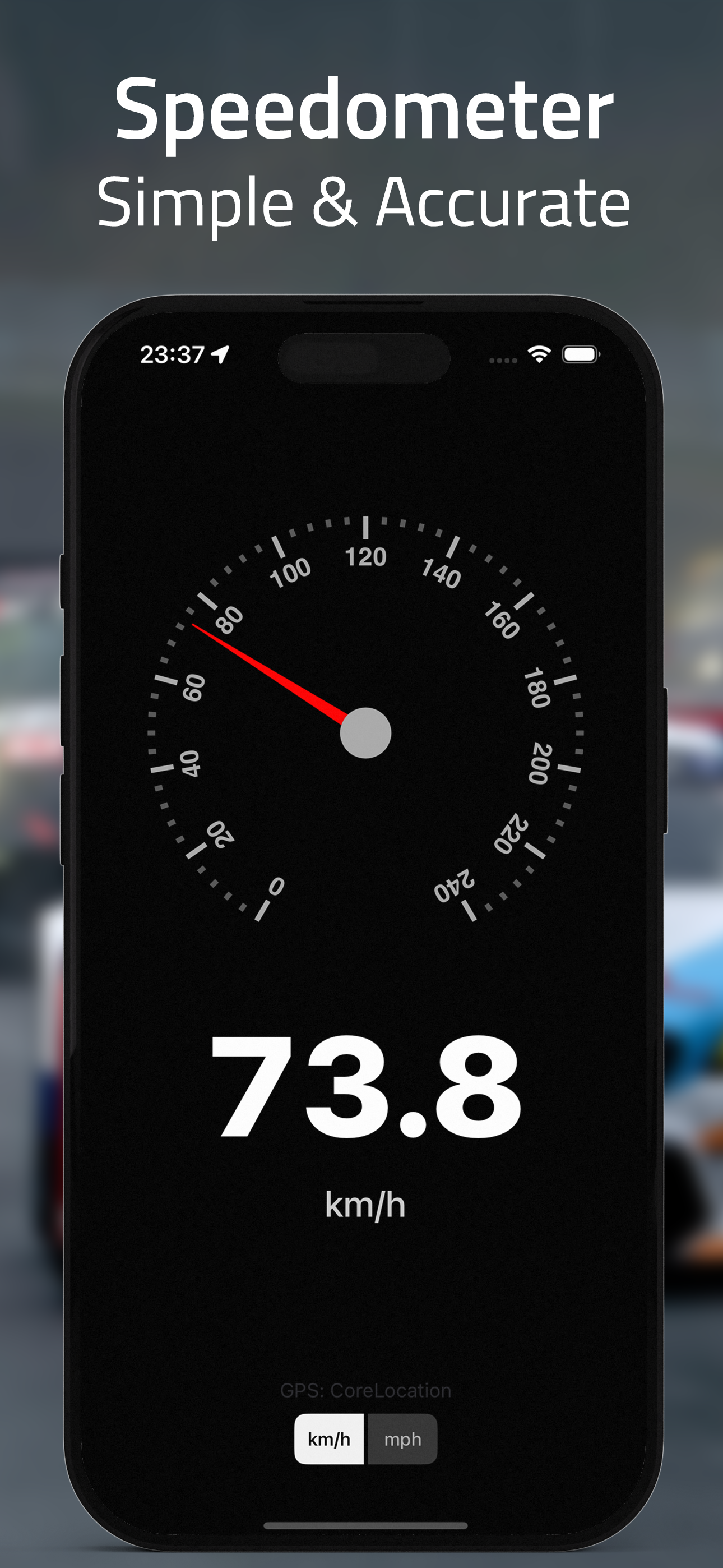
Speedometer Mode
Live GPS speed
Clean analog & digital modes
Switch between km/h and mph

Unit Converter
Supports 40+ unit types
From electricity to viscosity
Fast, accurate, and searchable

Batch Converter
Paste in multiple coordinates
Choose input & output formats
One-tap to convert all

Trim Mode
Customize trimmed output
Rename X/Y to any label
Control digits, format, and style

Calibration Mode
Shift, rotate, or scale
Apply map correction
Fix offsets and alignments

MapTiles
Choose from 50+ styles
Light, dark, or satellite
Supports offline & XYZ URL maps
Apple Watch Version

Coordinates on Your Wrist
In 2025, we rewrote the entire Watch app from scratch using Swift.
It’s faster, cleaner, and built specifically for your wrist.
View your live location in 10+ coordinate formats—UTM, MGRS, Plus Codes, and more.
Switch formats with a tap. Press the map button to toggle the map on or off.
🛰️ No phone? No problem. Works with built-in GPS on supported models.
We’re committed to building tools that professionals can trust in the field. Every improvement is shaped by real user feedback — and your input continues to guide us forward.
This is just the beginning. We’re actively working on new features, deeper customization, and smarter tools to support your workflow.
Thank you for being part of the journey — and rest assured, we’re not stopping here.
