
A New Era for Coordinates
Over 10 years ago, we launched Coordinates as a simple but powerful tool for navigating and converting locations. Since then, thousands of professionals around the world have used it in the field — from surveyors and engineers to GIS hobbyists and adventurers.
Now, after a full decade of iterative improvements, we’re proud to release Coordinates 9.5 — the largest, most meaningful update in the app’s history.
This version isn’t just about polish — we’ve rethought how you interact with your data. From drawing and saving shapes to a completely redesigned coordinate list and an all-new export/import system, Coordinates 9.5 fills in long-missing pieces. After years of steady evolution, this is the first version that truly feels complete — like the app we always envisioned it could be.
🟦 Draw & Save Shapes on the Map
You can now draw:
Lines
Polygons
Rectangles
Circles
Tap the new “Draw Shape” button to get started.

Once you tap the button, just trace your shape directly on the map — like this:

Directly on the map — with full control over:
Stroke color
Fill color
Line width
Dash pattern
Opacity

Each shape is saved just like a pin, label, or point — and can be exported, edited, or measured.
Use it to:
Map survey boundaries
Measure field plots
Annotate project areas
Visualize paths or zones
You’ll also get real-time stats: length, area, and radius, shown in your preferred units.
📦 Better GPX Support – Now with Shapes
For the first time, GPX export now includes lines, polygons, and circles — not just pins. While styling (colors, fill, opacity) isn’t preserved in GPX format, the shape geometry itself is retained, meaning your projects can now travel more easily between apps and devices.
This opens the door to new workflows, from exporting survey boundaries to overlaying shapes in GIS tools or sharing annotated paths with teammates.
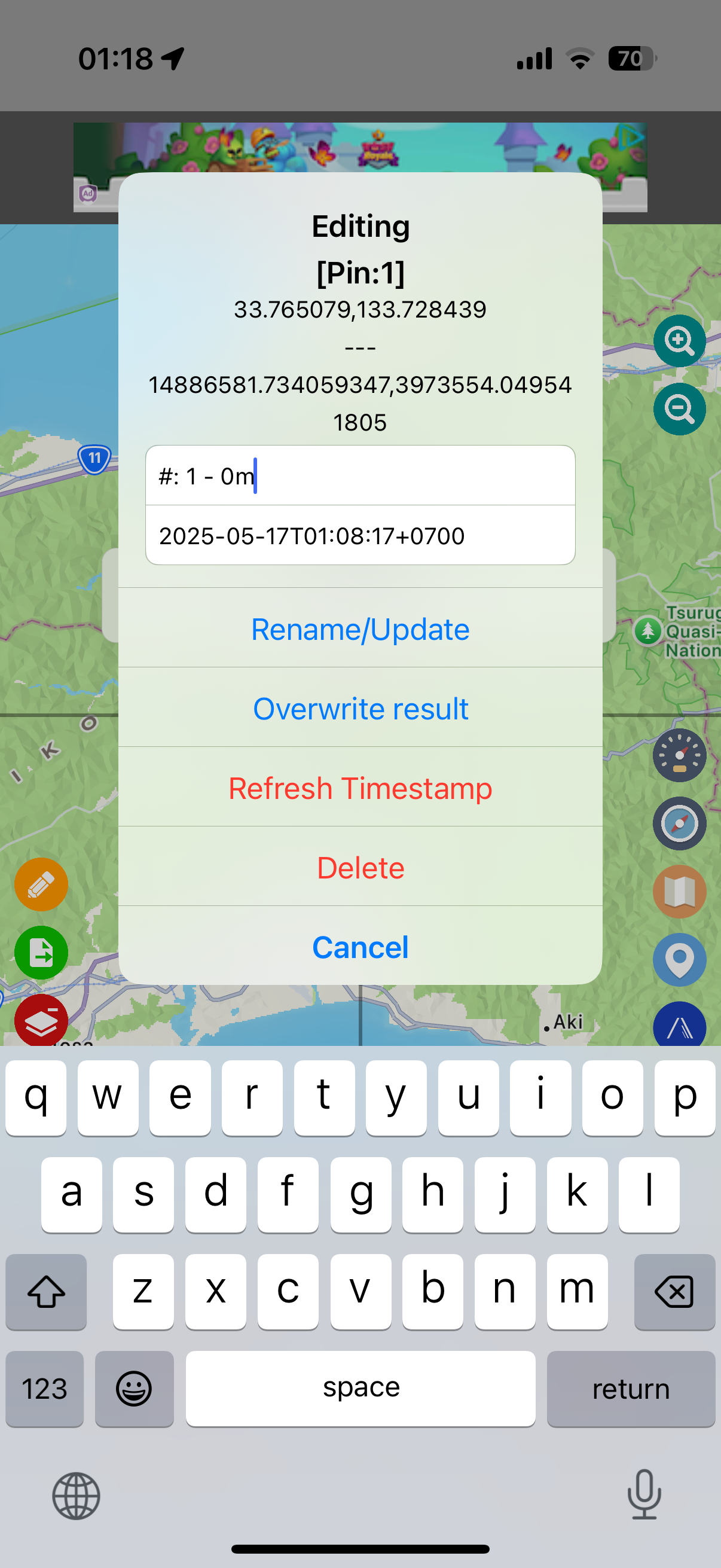
🟦 All-New Edit View: Smarter, Clearer, More Capable
The old popup for renaming pins did the job — but only barely.
In Coordinates 9.5, we’ve completely reimagined the Rename/Edit screen into a modern, full-featured editor for all map items — pins, shapes, and labels alike.
Now, when you tap to edit an item, you’ll see:
A map preview of the selected point or shape
Metadata including:
Timestamp
Coordinates (original and converted)
Shape statistics like area and perimeter
Editable title and notes
Options to refresh the timestamp or delete the item
Whether you come from the Map View or the List View, you’ll get the same consistent experience. It’s cleaner, more informative, and built for power users.
Bonus: Shape info like
radius,length, andareaare shown with correct units — metric or imperial — based on your settings.
Before

After
The new editor gives you a clearer overview and much more control — especially for shape-based objects
🟦 A Modernized Coordinate List
The coordinate list view has been redesigned from the ground up.
Object types (pin, label, shape) are clearly shown
Timestamps and converted coordinates are easier to read
Notes and labels now appear directly in the list
Sleek card-style layout works great in light and dark mode
Tap the new blue “List” button to view and manage all your map items

Here's how the new list looks in action:
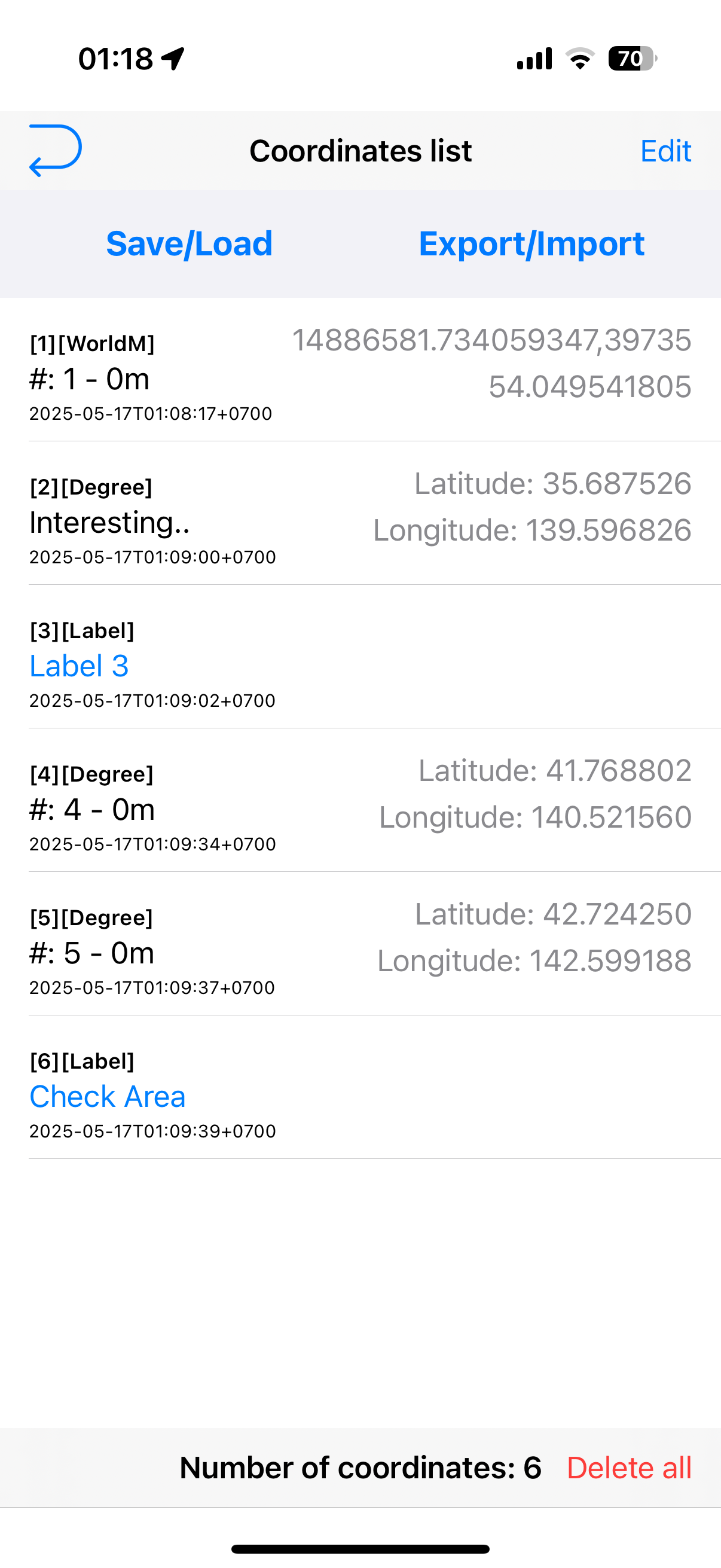
Before

After
The new list view not only looks better — it gives you clearer context, easier access to functions, and better visibility across all map item types.
🟦 Upgraded Saved Sets View
Managing your saved data is now effortless.
Each saved set shows a full-width map preview
See a summary of contents at a glance (pins, shapes, etc.)
Tap to rename, delete, or load instantly
Whether you’re organizing site visits or archiving survey results, this new view saves time and clicks.

Before

After
No more guessing what's inside — the new Saved Sets view shows you everything upfront, and it looks good doing it.
🟦 New Export & Import Workflow
You can now easily export any saved list — just select the one you want, and it’s ready to share or back up.
The new system uses a compact ZIP file format that bundles all your data cleanly — ready for cloud storage, email, or transfer between devices.
Want to bring data back in? Simply choose which lists to import, and they’ll be added to your coordinate sets instantly.
There’s no need to rely on the old XML format — this is faster, cleaner, and built for modern workflows.
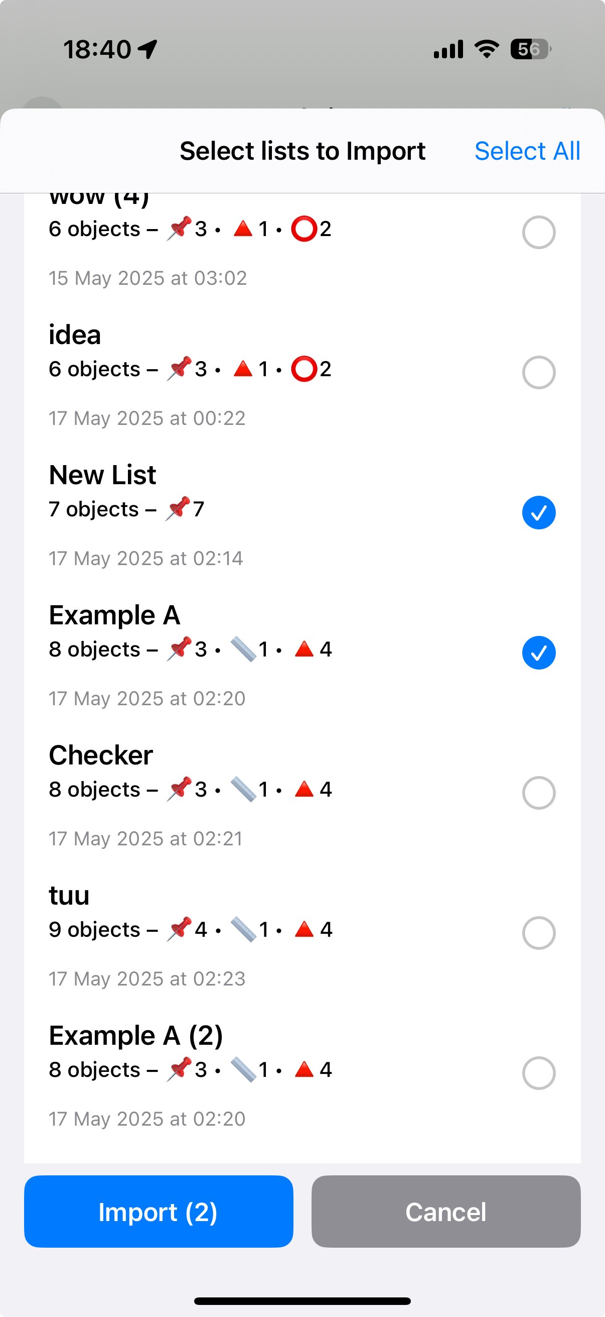
The new import screen gives you full visibility before merging — with set names, timestamps, and object counts all shown upfront.
🟦 Seamless Upgrade, Zero Learning Curve
Upgrading to Coordinates 9.5 is smooth and effortless.
There’s no setup, no migration steps, and no manual required.
All your saved pins, labels, and shapes remain intact
New features integrate naturally into your existing workflow
Everything just works — instantly
Whether you're opening an old project or starting something new, Coordinates 9.5 picks up right where you left off — smarter, faster, and more capable.
🟦 Bonus Feature: Signal Board
Need to get someone’s attention on-site?
The new Signal Board lets you display fullscreen messages in bold, animated styles — perfect for visual alerts, quick directions, or just having a bit of fun.
Choose from templates like SOS, Red Flash, or enter your own text in any language.
It works especially well on iPad, where the large display turns your message into a powerful visual signal.

🚀 Built for the Field. Ready for What’s Next.
Coordinates 9.5 isn’t just an update — it’s a redefinition.
We’re already working on what comes next:
Enhanced CSV/GPX/DXF import/export
Upcoming hardware support (e.g. external GPS, sensors)
And much more
We thank you for being part of this journey — and we can’t wait to see where you take Coordinates next.
🟢 Download Coordinates on the App Store
✉️ Feedback? Contact us here